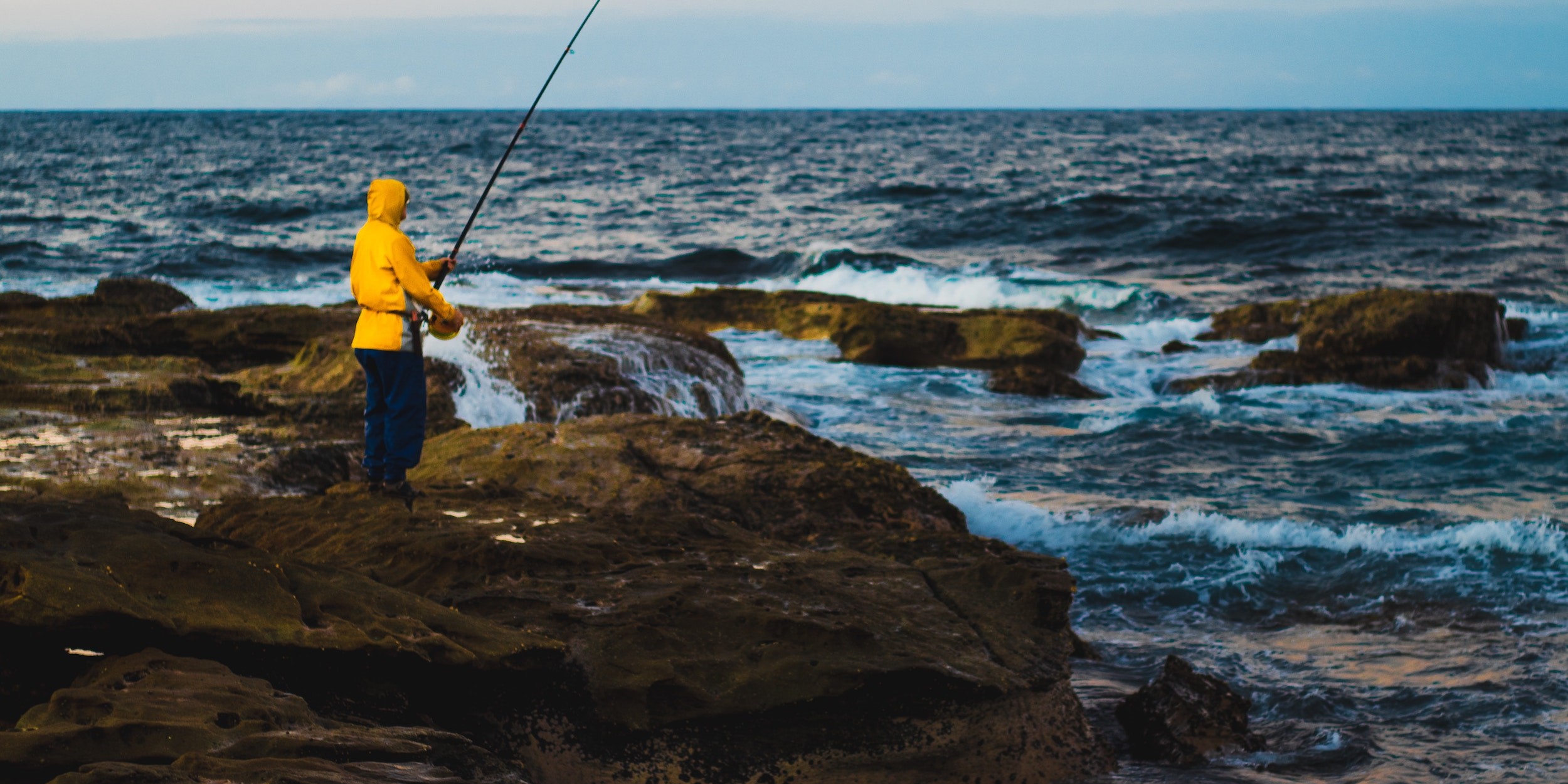
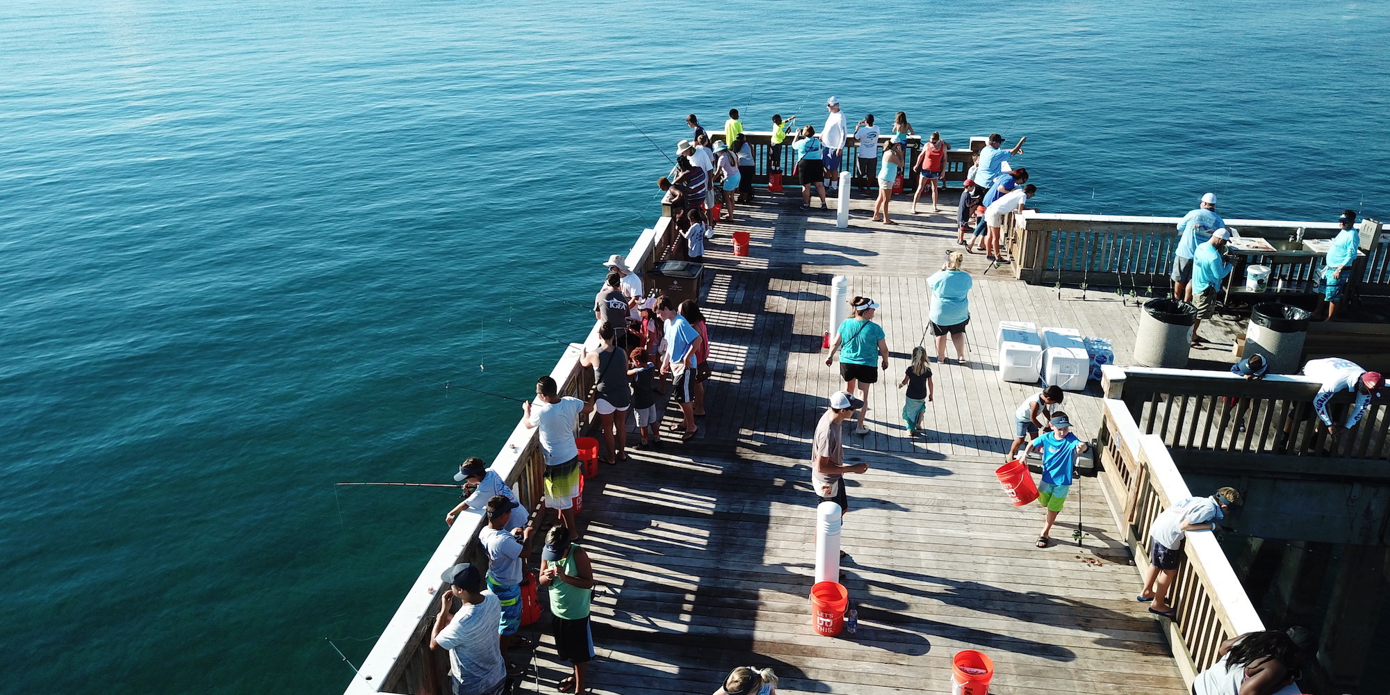
Planning the perfect day of fishing can seem like an unattainable task. Friends always insist the bite was better and the fish were bigger yesterday. FishAngler aims to end this cycle of never being on the water at the right time.
Don’t have the FishAngler app? Download it for FREE now:


The details offered by the FishAngler Forecast menu are your key to arriving at the right time, every time. The menu options offer hour-by-hour data for every type of fishing, from west coast rivers to midwest bass lakes, and all the offshore fishing you can handle.
 Below, we explore every feature the FishAngler Forecast feature has to offer. Check out how these charts can help you make every day fishing as good as your best day.
Fish Forecast
For those without the luxury of a full day of fishing, even if you pick the right day, you need to be fishing at the right time. The Solunar Theory is the theory that animals, as well as fish, will have peak times of activity during the day. The moon phase score, moon distance score and Solunar coincidence score are all used to help you determine the highest level of fish activity every day. This information will appear on your screen as an easy-to-read fishing chart.
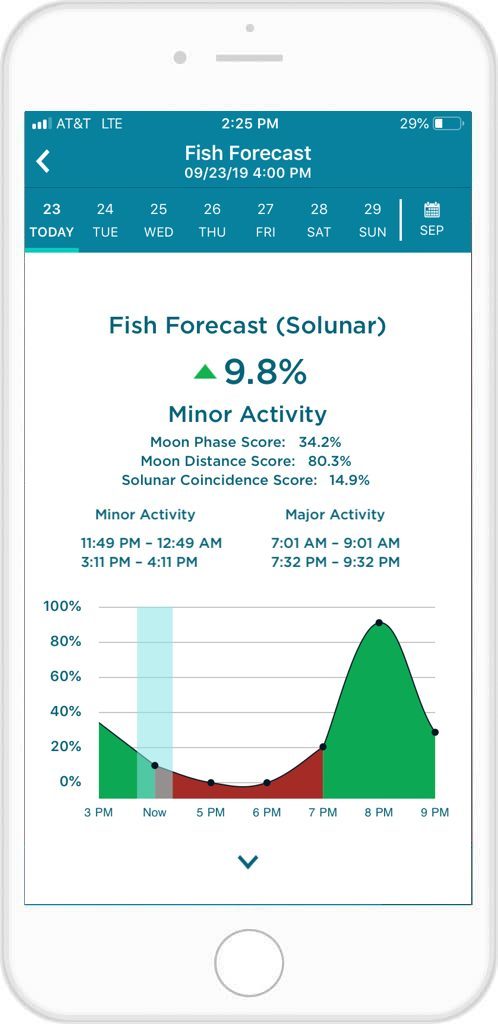 The best times of day to fish will appear on your screen as green spikes with corresponding times. Typically, there will be four peaks a day when the fishing should be at its best. Two of these spikes will be major rises in activity, while the other two will be considered minor. You can also see the approximate time of these peak fishing windows at the top of the chart.
Note that the fish are still there, even when the percentage likelihood of catching them aren’t as high. We simply provide you with the tools to help optimize the time you do have on the water.
Weather Forecast
Your day on the water can depend heavily on what Mother Nature is about to throw at you. Some fishing can be incredibly weather-dependent. To keep you constantly informed of daily weather patterns, the FishAngler app uses NOAA weather data to provide you with the most accurate temperature, pressure, humidity and precipitation chance for the day.
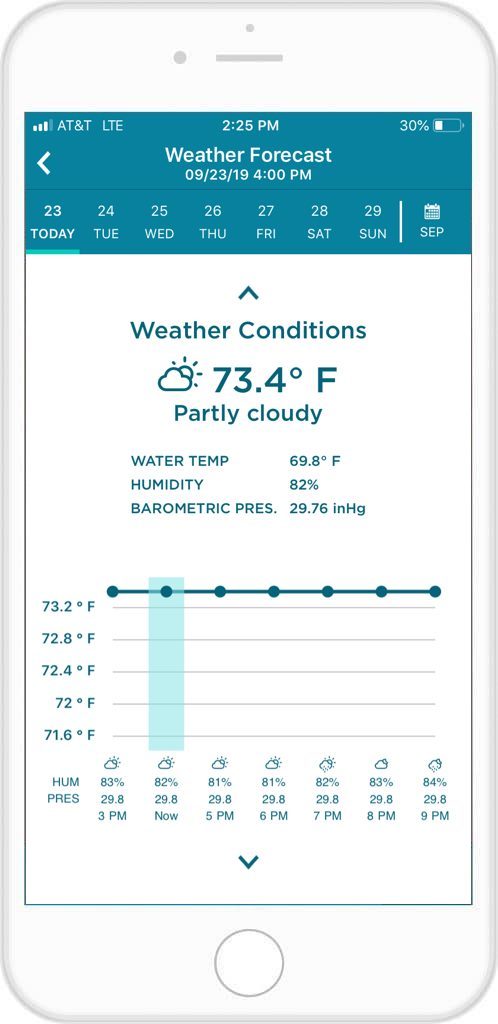 The temperature is featured on a digital chart, which will show the highs and lows throughout the day, by the hour. The other weather conditions are presented as percentages above your chart for quick and easy reading.
You can look up weather weeks in advance. Though, as fickle as the weather is, this can be subject to change.
Barometric Pressure
Detail-oriented anglers and hunters live by barometric pressure. This one clue can reveal a lot of information regarding fish movement.
Fish are sensitive to changes in atmospheric pressure as it plays an effect on their swim bladder. Fish will often dive deeper during a low pressure system and feed more actively when pressure rises.
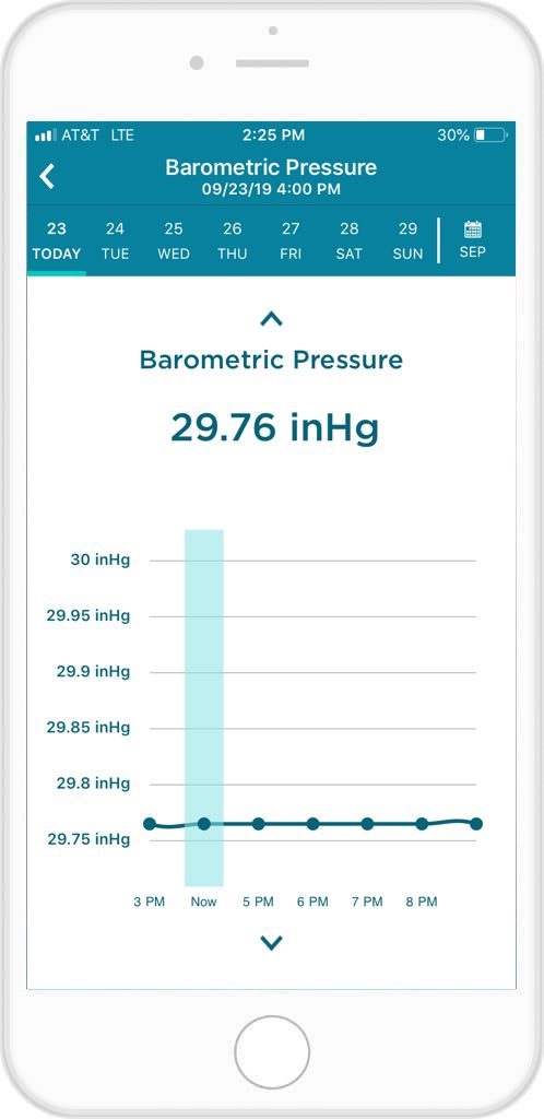 Your FishAngler app will detect the daily rises and falls of pressure and present the information to you in an easy-to-read chart. You don’t have to be a meteorologist to understand it! Pressure will be displayed as a line graph, showing you the pressure patterns throughout the day.
The graph will display the exact figures of pressure measured in “inHg”, or inch of mercury, a unit of measurement for pressure. But all you need to know is whether your handheld barometer is rising or falling.
Wind Forecast
Any angler knows, wind can be tricky to deal with. Shifting winds can have you constantly casting into gale forces, or making wakes across your once glass-like lake. Offshore anglers have even more to worry about with wind patterns. They can make the water unsafe for even the stoutest of captains.

Wind Conditions will show a daily bar graph, displaying wind speed and direction. Data is by the hour with gust speeds also available at the top of your chart.
Wave Forecast
For offshore anglers, wave size and direction can mean setting sail and staying ashore. Wave Conditions give you the size of swells, direction, and frequency of the day’s wave patterns on your chosen section of water.
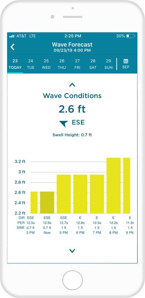
The information reads as a bar graph set against all the information you need to hit the open water.
Tide Forecast
Tide phases are another important factor that all offshore anglers need to know. With your Tide Phases forecast, you can pick the exact area you are looking to set out on and have the height and pattern of the tides for that day.
Tide Forecast will also give you: tide height, time of next tide, previous tide, high tides and low tides.
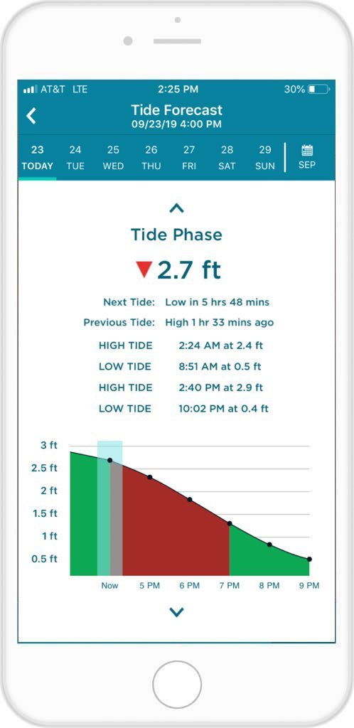
Your tide data is set against an easy-to-read graph and will have a corresponding line, indicating the rise and fall of your water’s tides that day.
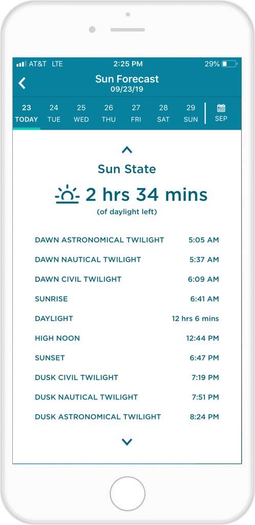
Sun Forecast
The Sun State provides you information about the sunrise, sunset and everything in between. You will have in your palm the exact amount of daylight for your daily fishing endeavors, and how much time is left before sunset.
Other information provided for you: dawn astronomical twilight, dawn nautical twilight, dawn civil twilight, amount of daylight, high noon, dusk civil twilight, dusk nautical twilight, and dusk astronomical twilight.
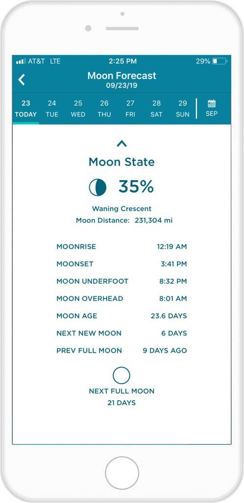
Moon Forecast
As with the Sun State, you will have all the information you could possibly need regarding the Moon State and lunar activity.
Moon State provides users with: moon phase, moon distance from Earth, moonrise time, moonset time, moon underfoot time, moon overhead time, moon age, next new moon, previous full moon, and the next full moon.
Water Level
The Water Level screen is accessible when a Gauge location is selected at the top of the Forecast menu and is available for some streams, rivers and other bodies of water.
This forecast takes into account varying circumstances that may impact water level, such as how much precipitation has fallen in the recent past and precipitation amounts anticipated in the next 24 hours.
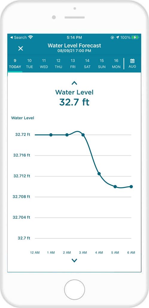
The Water Level screen tells you how water height is predicted to change from hour-to-hour over a 24 hour period via a handy line graph.
Water Flow
As with Water Level, Water Flow is accessed by selected a Gauge location at the top of the Forecast menu. Water Flow measurements indicate the amount of water that is flowing past a specific point in a stream at a given time.
A number of factors can influence the amount of water flowing through a body of water at any given time, such as precipitation, season, stream shape and local groundwater conditions.
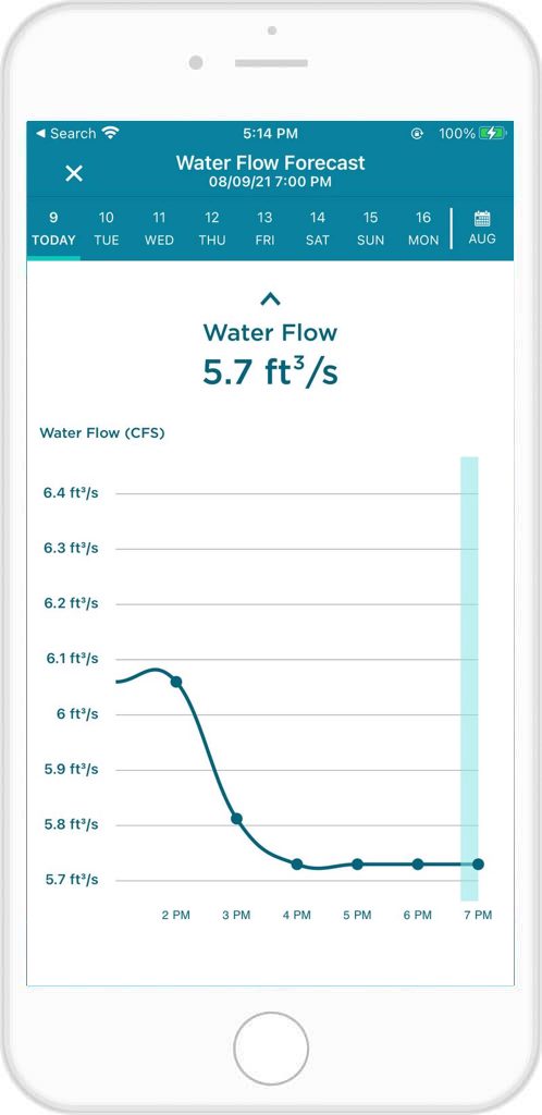
Flow is typically recorded in cubic feet per second (CFS) or cubic meters per second (CMS).
FishAngler’s Forecast menu is your best tool for understanding fish, the elements that impact their behavior, and determining the best times to fish! Take advantage of this wealth of knowledge available at the click of a button.
Download the FishAngler app for FREE!