Public land fishing access is an ever-evolving landscape across the U.S. But with the launch of FishAngler’s new Public Lands Layer, finding your next fishing spot has never been easier. Whether you’re casting a line in a local city park or planning a trip to a national forest, FishAngler has mapped millions of acres of potential fishing territory. Let’s explore some of the most common types of public lands available for fishing and how to use this new feature to access prime water near you.
Don’t have the FishAngler app? Download it for FREE now:
![]()

Why Public Lands Matter for Anglers
Public lands provide a wealth of opportunities for anglers. From state parks to national forests, these lands offer open access to fishable waters. However, rules vary by location, so it’s crucial to familiarize yourself with the specific access laws and regulations in each area.
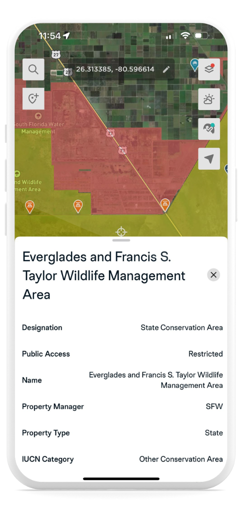
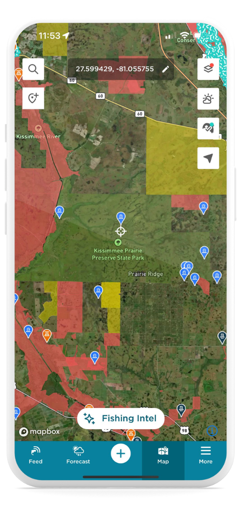
Tip: Public access areas are highlighted in green on the map. Tap any green, yellow or red shaded area to view detailed information about the land, including its name, access type, and acreage.
Key Types of Public Lands for Fishing
- State Parks: Widely available and often rich with fishing opportunities, state parks can be found nationwide. They frequently feature lakes, rivers, and coastal access points, though some may require entrance fees or have specific regulations.
- National Forests: Primarily located in the western U.S. but also available in states like Virginia and North Carolina, national forests offer thousands of miles of fishable streams and lakes. Generally free to access, these areas are ideal for anglers seeking less crowded spots.
- National Parks: Renowned for their scenic beauty, national parks like Yellowstone and Everglades also provide excellent fishing. Be sure to check specific park rules, as many have special fishing licenses or restrictions.
- Bureau of Land Management (BLM): Covering vast areas in the West, BLM lands are great for extended fishing trips, offering free access to rivers like the Snake and Missouri.
- City Parks: Closer to urban areas, city parks often provide convenient access to fishing spots without entrance fees. They’re perfect for quick trips or a casual day on the water.
- Fishing Access Sites: Designated specifically for anglers, these sites allow you to launch boats or fish directly from shore. They’re typically free and easy to find through the FishAngler map.
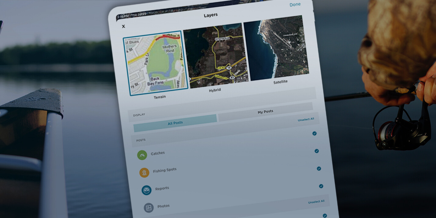
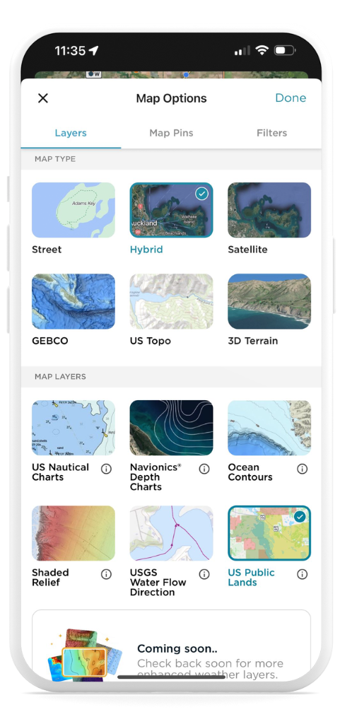
How to Access Public Lands on FishAngler
Getting started with the Public Lands layer is easy:
- Open the Map on the FishAngler app.
- Tap the Map Options icon in the upper-right corner.
- Select Public Lands from the available layers.
- Confirm Your Selection: Tap “Done” in the upper-right corner to activate the Public Lands layer.
- Tap on the shaded areas to explore the type of land and any relevant information, including acreage and access details.
Make the Most of Your Fishing Adventures
Public lands are an incredible resource for anglers. Whether you’re exploring vast wilderness areas or nearby parks, FishAngler’s Public Lands layer gives you the tools to plan your next fishing trip with ease.
Don’t have the FishAngler app? Download it for FREE now:
![]()